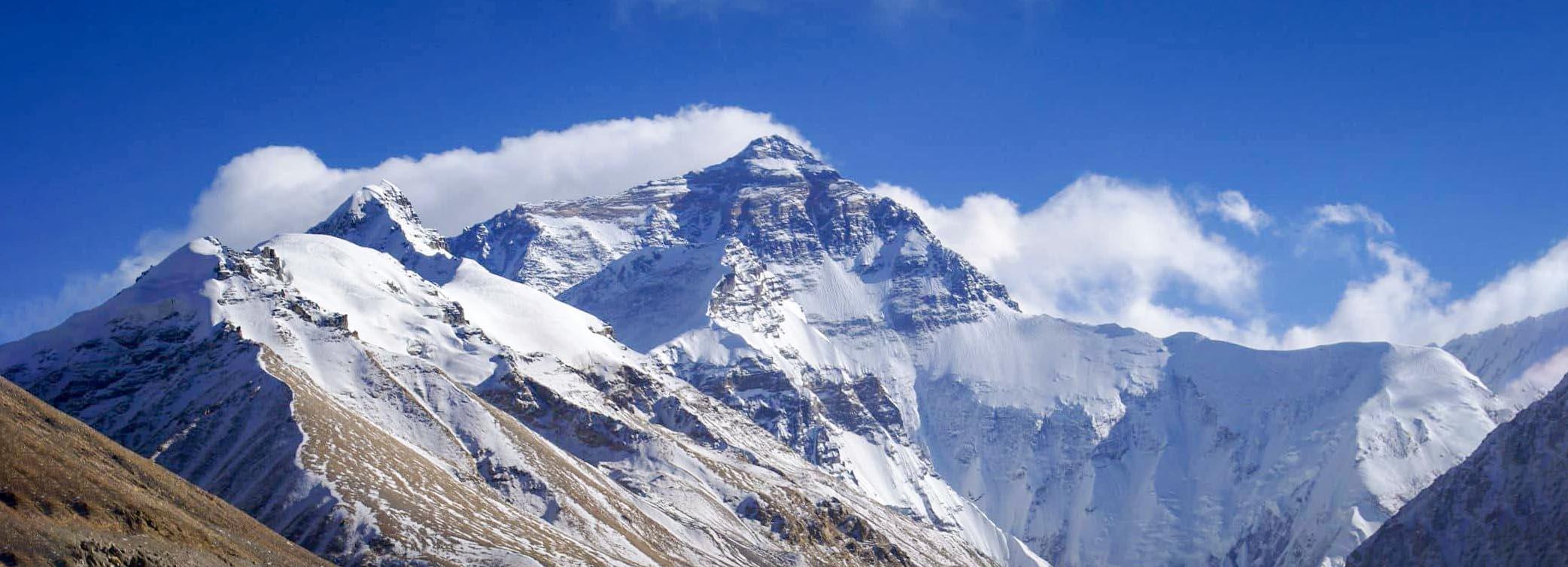
नेपालको उत्तरीसीमा नगराज हिमालयका विपुल हिमश्रृड्.खलाहरुद्धारा सुरक्षित छ । ती श्रृड्.खलाहरुमा विश्वकै सर्वोच्च शिखरस्वरुप रहेको सगरमाथा एवं तिब्बतको सीमामा अवस्थित छ । यसको उत्तरमा तिब्बतको चड.् प्रदेश छ भने नेपालमा किरात प्रदेश छ । यसैले यस हिमशिखरलाई इन्डो आर्यन् तथा तिब्बती भाषामा के नामकरण गरिएका छन् भन्ने कुराको खोजीमेलो गर्ने कार्यमा इतिहासकार दिवंगत श्री बाबुराम आचार्यले नेपालीहरुमा सर्वप्रथम पहल गरेका थिए । उनले आफ्नो अनुसन्धानद्धारा विश्वको यस सर्वोच्च शिखरको तिब्बती नाम झ्यामोलोड.मा औ संस्कृत नाम सगरमाथा भनी ठम्याए । तदपरान्त सगरमाथाको नामले यो शिखर विख्यात छ । यसरी इतिहासशिरोमणि श्री बाबुराम आचार्यज्यूको यस अनुसन्धानले इतिहासकारहरुको लागि एक प्रकारको गोरेटो निर्माण गरिदिएको छ । उनले बाठमाडाँैबाट प्रकाशित हुने वि.सं. १९९५ पौष महिनाको शारदा मासिक पत्रिकामा प्रकाश भएको “सगरमाथा या झ्यामोलोड.मा“” नाम गरेको आफ्नो एक लेखमा सर्वप्रथम यो शिखरको नेपाली नाम सगरमाथा भनी उल्लेख गरेका थिए । यस सर्वोच्च शिखरको प्राचीन वा पौराणिक नाम ‘नगाधिराज’ हो । नग भनेको पर्वत र पर्वतहरुमा सर्वश्रेष्ठ भन्दाखेरि नगाधिराज भनिएको हो । समस्त देवताहरुबाट पूज्य नगाधिराज ‘देवतात्मा’ अर्थात देवताहरुको आश्रयस्थल मानिन्छन् ।
यी हिमश्रृड्.खलाहरु समुद्र सतहदेखि करिब चार हजार आठ सय ७७ देखि आठ हजार आठ सय ४८ मिटरसम्म फैलिएर रहेका छन् । नेपालको उत्तर दक्षिण २५ कि.मी.देखि लिएर करिव ५० कि.मी जतिको चौडाइमा रहेका यी हिमालहरुले कुल क्षेत्रफलको करिब १५ प्रतिशत भूभाग ओगटेर रहेका छन् ।
संसारको प्राकृतिक संरचनामा सर्वोच्च नगाधिराज, पर्वत शिखर सगरमाथा समस्त मानाव जातिकै आकर्षण र साहसीहरुको गन्तब्य वा आरोहणको केन्द्र बनेर रहेको छ । महालङ्गुर पर्वतशृड्.खलामा पर्ने प्रस्तुत हिमशिखरको उचाइ आठ हजार आठ सय ४८ मिटर वा २९ हजार फिट रहेका छ । सर्वप्रथम २९ मे, १९५३ मा तेञ्जिड. नोर्गे र एडमण्ड हिलारीले सफल आरोहण गरेपछि नगधिराज सगरमाथा विश्वव्यापी चर्चाको विषय बन्न पुग्यो । बेलायतका सर्भेयर जर्ज एभरेष्टले नेपालको हिमशिखरहरुको सर्वेक्षण गरेकाले उनैको नामबाट नगाधिराजलाई Mount Everest भन्ने अन्तराष्ट्रिय नाम दिइएको हो ।

विश्वको सर्वोच्च शिखर सगरमाथाको बारेमा केही तथ्य यहाँ प्रस्तुत गर्ने जमर्को गरेको छु ।
1 “ The Discovery in 1852 that EIOUOQPeak XV was the highest mountain in the world emerged from a page of routine survey calculation when a clerk in the Trigonometic survey of India office excitedly informed his superior of his discovery, acareful check of his calculations which were based on observations made three years earlier, confirmed his claim and the summit was set 29,00 feet. (Careful modern observations have settled on an elevation of 29,028 feet, the valu now generally accepted.) Peak XV now rated mare distinction than a file number and was given the name Mount Everest after the first surveryor General of India, Sir Goerge Everest . There was no way then of knowing at the Tibetans long ago recognized if as the greatest of mountains and called if chomolongma, Goddess Mother of the world.
हेर्नुस् -Thomas F. Hornbein “Everest: The West Ridge”, Introduction Villiam E Siri, Vikas Publishing House Pvt. Ltd., 1980, P. 16; Everest mount 27 59N 86 56E. The highest mountain in the world, on the Nepal—Tibet border in the Himalayas . It was recognized as the highest in 1852, but the height itself was not established until 1955….. Height 8848m(29028fit.) हेर्नुस् The Macmillan Encyclopedia, First published 198, Macmillan London Limited, London, P.428;
माउन्ट एभरेष्ट नेपाल र तिबेतको सीमानामा देखाइएका केही उदाहरणहरु निम्न मानचिरहरुमा पाइन्छनन् ।
१) १८६५(६७ को Peterman’s Map of Tibet
२) १८७७ ई. को Sander’s Map of the Himalays and Tibet
३) १९११ ई.को Stylers Hand Atlas Map No 62
४) १९४७ ई. का Wall Map of Modern China
५) १९५१ ई. को Wall Map of the people’s Republic of China
६) १९५१ ई. का Big Map of the people’s Republic of China
चीनले सयम समयमा प्रस्तुत शिखरलाई आफ्नो भूभाभित्रै परेको कुरा देखाउने प्रयास पहिलेदेखि नै गर्दै आएको कुरा निम्न मानचित्रहरुको अध्ययनबाट जान्न सकिन्छ ।
१) १९५६ ई. को Chinese Aeronautical Map
२) १९५५ई को Map of The Gre Motheraland
३) १९५६ ई. को The Wall Map of the people’s Republic of China
४) १९५९ ई. को The Qall Map of China हेर्नुस् चित्तरंजन नेपाली ः नेपाल( चीन सीमाना सन्धि, श्री ५ को सरकार, पञ्चायत मन्त्रालय, प्रचार विभाग, वि.सं. २०२१
५) हरिराज जोशीः नेपालका प्राचीन अभिलेख, ने.रा.प्र.प्र. २०३०,पृ.३५०
६) Sircar: Select Inscriptions, University of Calutta, 1965, PP. 336, 346.
७) “…the people of Dud Kosi area call it Svarga –math or sarag—matha” Swami Pranavanda: Exploration in Tibet, University of Calcutta, 1950, P.4
८) Brain Hodgson: Essays on the Languages Literature and Religion of Nepal and Tibet, Manjusri Publishing House, 1972
९) हेर्नुस ibid
१०) सर्ग – emission or Creation of matter, Primary Creation, Creation of the world
- Sir M. Monier Williams;
Sanskrit English Dictionary, 1981, P. 1184;
“अश्याः सर्गविधौ प्रजापतिरभूच्र्चद्रो नु कान्तिप्रदः”
विक्रमोर्वशी १.१०
“तिसृभिस्त्वमवस्थाभिर्महिमानमुदीरयन् ।
प्रलयस्थितसर्गाणामेकः कारणतां गतः ।।६िि
कुमारसम्भवे द्धितीयः सर्गः
११) a way, road
- Sir M. Monier Williams:
Sanskrit English Dictionary, 1981, P. 808; V.S. Apte : The Student’s Sanskrit English Dictionary, 1968,P. 434
१२) शारदा (मासिक) तथा नेपाली गद्य संग्रह, भाग १ मा प्रकाशित बाबुराम आचार्यको लेख ।
१३) Lung, Lungba, Lungma or Lungh- Valley
-Swami Pranavananda: Exploration in Tibet, P.263;Lung-pa-Valley
– Charles A. Bell : Manual of Colloquial Tibetan, Ratna Pusta Bhandar, Kath, 1978, P. 529;
Lungma (Tibetan), Lung(Bhutan)- air, Lung(Limbu) – store
-Brain Hodgson: Essays on the Languages Literature and Religion of Nepal and Tibet, Manjusri Publishing House, 1972
१४) स्व. श्री ५ महेन्द्रको इङ्गलैण्ड भ्रमणको अवसरमा Royal Geographical Society ले तयार गरी तत्कालीन श्री ५ महेन्द्रको हजूरमा टक्र्याएको नक्सामा माउन्ट एभरेष्ट र चोमोलुड्मा दुवै नाम दिएको छ ।
१५) १९०७ ई. नेपाली सर्भेयरद्धारा तयार गरको नक्सामा माउण्ट एभरेष्ट र चोमोलुडखमा दुवै नाम दिइएको छ ।
१६) १९५८ ई. मा पेकिङ्गबाट प्रकाशित A Simple Geography of China मा चामोलुड.मा नाम पनि दिइएको छ ।
१७) १९५५ ई. पछि प्रकाशित अधिकांश चिनियाँ नक्शाहरुमा यो शिखरको चोमोलुड.मा नाम नै व्यवहृत छ ।
१८) -Charles A. Bell:Manul of Colloquail Tibetain, 1978, P223, Kang Snow
१९) – Brain Hodgson: Essays on the Languages Literature and Religion of Nepal and Tibet; ri-mountain, Knagri- Snowy mountain
- Charles A. Bell: Manual of Colloquial Tibetan.1978 P,321:
Kang-ri Snow mountain, glacer or Kailash
-Swami Pranavananda: Exploration in Tibet. P. 262
२०) Brain Hodgson को अनुसार नेपालका मानिसहरु यो शिखरलाई देवढुङ्गा नामले पुकार्दथे ।
२१) चित्तरंजन नेपालीः नेपाल चीन सीमाना सन्धि, प्रचार विभाग, २०२१, पृ.५६
२२) Cho-Tibetan Great antelope (Pantholops Antelope)
-Swami Pranavanda : Exploration in ibet, P. 260
इतिहासविद्ध तथा संस्कृत शिरोमण हरेराम जोशीज्यूलाई
विशेष धन्यवाद कुराकानीको लागि ।


Recent News

- July 13, 2023
पुरुषोत्म मास महत्व

- May 25, 2023
आज सिथी नखःपर्व

- April 14, 2023
इलामको नयाँ पदमार्ग “निशान पदमार्ग”

- November 05, 2022
हिन्दू पर्यटकहरुको लागि चार नारायणको गन्तब्य

- October 21, 2022
म्ह:पूजा र मण्डलाको महत्व
Newsletter
Subscribe to our mailing list to get the new updates!

Subscribe our newsletter to stay updated